GARMIN GPSMAP 1022xsv

Overview
Garmin GPSMAP 1022xsvs is a marine GPS navigator with integrated advanced sonar. It is equipped with a large 10" display with button control and the option to connect Garmin Network devices (radar) + NMEA 2000 devices. Full compatibility with the NMEA 2000 protocol allows you to connect devices from the GPSmap 1022xs series to a number of compatible sensors, devices and additional devices - and so you can monitor all important data such as navigation, fuel status, engine and weather info on one display.
The main advantages of the GPSMAP 1022xs combine a GPS navigator (10Hz GPS/GLONASS) and a high-quality sonar in one device. New - control menu in the dashboard.
CHIRP Sonar - properties and parameters
Available with power up to 1 kW traditional; 1 kW CHIRP (RMS), which supports the following technologies - Traditional: 50/77/83/200 kHz and ClearVü: 260/455/800 kHz and SideVü: 260/455/800 kHz The device package includes an ultrasonic probe GT52HW-TM ( Traditional CHIRP High-Wide: 150/240 kHz @ 24/16° + ClearVü CHIRP 455 kHz & 800kHz + SideVü: 260/455/800 kHz).
A wide range of optional probe types for specific use Garmin
> > sonar technologies < < < enable the expansion of the available sonar parameters, or in addition to the standard mounting (on a mirror) you can choose a probe with an inner hull or through-hull assembly. It is enough to additionally choose a suitable probe from our wide range according to the requirement.
Free functional software extension on compatible Garmin GPS sonar and marine navigators. The Quickdraw Contours function allows you to simply use the sonar to "scan" the bottom and create a detailed bottom relief map anywhere. The resulting HD maps with noise contours (approx. 30 cm spacing) remain saved as a map and are immediately ready for sharing via the service - Garmin Quickdraw™
Display of detailed graphics and video
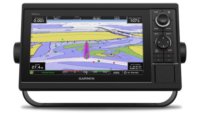
Thanks to the high resolution of the display and fast processor, the device redraws and displays marine maps (BlueChart® g2 vision)No problem. In the basic equipment, it offers a pre-installed basic map of the world, which is created from satellite images of the earth. Intuitive control provides the user with simple and clear operation.
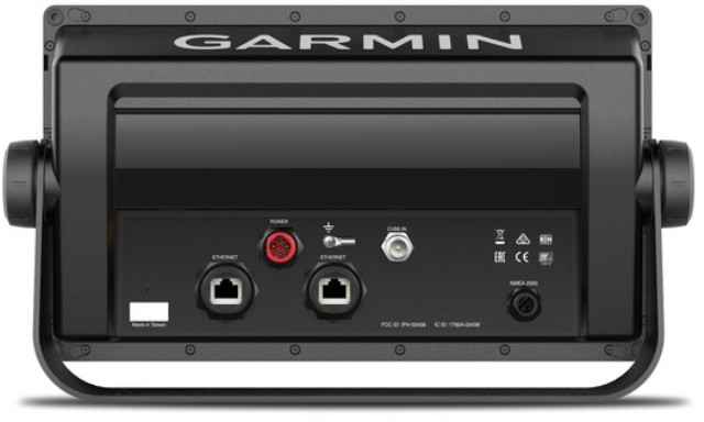
Marine navigation The BlueChart® g2 / g2 vision edition brings a new dimension to marine navigation with display in 3-D mode (above and below the surface of the water), plus useful Auto Guidance on detailed high-resolution backgrounds and aerial images of ports, marinas, waterways, navigational markings and other points of interest (POI). The device is equipped with an available 2 x SD memory card slot. Support for networking via NMEA 2000 & NMEA 01083
Content :
- GPSMAP 1022xs
- Marine mount / bracket with mounting kit
- Flush mounting kit
- Power/data/sonar cable
- Plastic protective cover
- NMEA 2000 T-connector
- NMEA 2000 drop cable (2 m)
- 8-pin adapter to 12-pin for ultrasound probes
- Technical documentation
- User manual
Parameters :
| Dimensions and features: | : |
| Device dimensions, WxHxD: | 31.8 x 18.5 x 6.9 cm |
| Display - size, WxH: | 22.4 x 12.5 cm |
| Display - resolution, WxH: | 1024 x 600 pix. |
| Display - diagonal, "; cm: | 10" |
| Display - type: | WSVGA |
| Touch screen: | Not |
| Device weight: | 1.85 kg |
| Power supply: | external (12-24V) |
| Water resistance: | Yes IPX 7 |
| Swimming on the surface: | Not |
| GPS receiver: | GPS + GLONASS (10Hz) |
| High-sensitivity receiver: | Yes |
| Portable: | Not |
| Maps and memory: | : |
| Pre-installed maps: | Basic world map (satellite images) |
| Built-in memory: | ON THE |
| Memory usage cards: | SD (2 slots) |
| Waypoints/Favorites/Positions: | 1500 |
| product_web: | 35689, 448, 448 |
| Features and equipment: | ----------------- |
| Track log | |
| Track log / route recording and management: | 10,000 points/20 routes |
| Qwerty or ABC keyboard: | Not |
| Available sonar power (RMS): | 1 kW (Traditional sonar) / 1 kW single channel CHIRP |
| CHIRP ClearVü (260/455/800 kHz): | Yes (built-in) |
| CHIRP SideVü (260/455/800 kHz): | Yes (built-in) |
| CHIRP traditional sonar (low, mid, high): | Yes (built-in) |
| Panoptix probes (support): | Yes (supports) |
| Quickdraw Contours (support): | Yes |
| Traditional sonar (50/77/200 kHz): | Yes (built-in) |
| Tide Tables: | Yes |
| AIS support (sending and receiving positions): | Yes |
| Maximum depth (scanning depth range: | According to the probe used |
| Cone (scanning angle): | according to accessories |
| NMEA input/output: | NMEA 0183 / NMEA 2000 |
| Audible alarms/vibration: | Yes No |
| Split-screen zoom: | Yes |
| DSC support (sending and receiving positions): | Yes |
| XM WX Weather & Radio for US compat.: | Yes |
| Link: | series |
Features
Brand | GARMIN |
| Bonus name | Discount | Discount, % | Affiliate |
|---|---|---|---|
| Cash Back 5% | 0 | 18742.47 |
Be the first to write a review of this product!